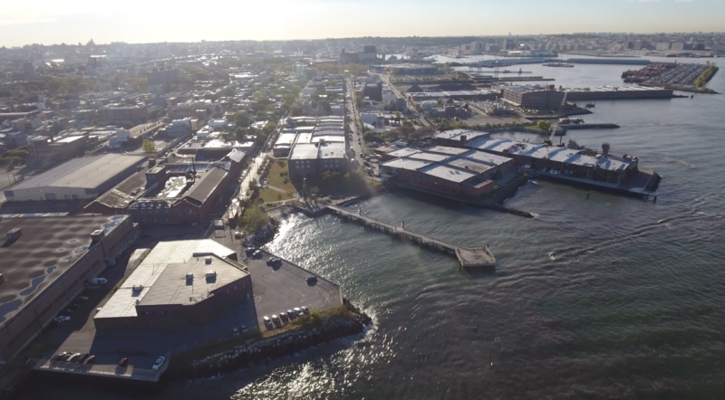
With its 578 miles of shoreline, New York City is never far from the water, but few neighborhoods are more defined by their proximity to the blue than Red Hook. This isolated peninsula in southwestern Brooklyn sticks out into New York’s Upper Bay like a boxer’s chin, and water surrounds it on three sides, with the fourth walled off by the man-made river that is the Gowanus Expressway. During its late 19th century heyday, that location made Red Hook for a time the busiest freight port in the world and the center of New York’s lucrative cotton trade. When the maritime trade moved away from Red Hook after World War II, the neighborhood fell into steep decline, but today Red Hook is on the rise again, as first artists and now increasingly wealthy professionals have moved into the area, attracted by its independent spirit—and those water views.
But on Oct. 29, 2012, the water turned against Red Hook. The winds of Hurricane Sandy, striking at high tide, created a massive storm surge that pushed hundreds of millions of gallons of water onto and over New York’s shoreline. The resulting flood would cause $19 billion in damage throughout New York City, killing dozens of people, but Red Hook, which is so low-lying that nearly the entire community fell with the city’s mandatory evacuation zone, bore some of the worst of the storm’s wrath. As the Sandy-whipped water spilled over bulkheads along the shore, Van Brunt Street, Red Hook’s main thoroughfare, became a raging river, and nearly every other block in the neighborhood was inundated. Basements and cars were flooded out, and water even spat up from the sewers.
Part one of a three-part special report from The Bridge
The Fairway supermarket that sits inside a brick and wrought iron Civil War-era dock building was ruined, and wouldn’t reopen for nearly six months. The most lasting damage was done to the Red Hook Houses, a cluster of subsidized rentals where more than half of the neighborhood’s 11,000 residents live. The buildings lost access to power and clean water for weeks as the city’s Housing Authority struggled with the widespread damage, and were left ridden with mold by the floodwaters. “Red Hook was hit really hard,” says Jill Eisenhard, the executive director of the Red Hook Initiative, a community-focused nonprofit. “The storm was the disaster that we all feared.”
Yet five years later, virtually all visible signs of Sandy have vanished from Red Hook, and indeed much of New York. Homes and businesses have largely been repaired, and new residents, far from being scared off by the storm, are flocking in. New Red Hook buildings like the Basis Independent Brooklyn school have gone up in the years since Sandy, and pricey new condos are emerging on the neighborhood’s waterfront—so much so that in the third quarter of this year Red Hook became Brooklyn’s priciest neighborhood based on new-home sales.

In the aftermath of Sandy, Red Hook residents were served meals at the Red Hook Initiative community center (Photo by Radhika Chalasani/Redux)
Defenses against the next storm are rising too. In Red Hook, that began with the installation of an interim flood barrier along Beard Street, and will grow to include a more permanent, $100 million Integrated Flood Protection System for the neighborhood. At the same time, Red Hook Houses are being repaired and renovated as part of the $3 billion the Federal Emergency Management Agency has allocated to New York to shore up the city’s housing projects, which were badly damaged by Sandy.
Altogether New York is allocating $20 billion on post-Sandy disaster recovery and resilience, enough to put the city at the forefront of national efforts to get ahead of the impacts of storms, floods, and climate-change-related sea-level rise. “We’re certainly better prepared now for the next storm in a number of ways,” says Robert Freudenberg, vice president of energy and environmental issues at the Regional Plan Association, a think tank that focuses on the metropolitan area. “New York has laid out a clear blueprint of what needs to be done to protect from future storms, and that’s far ahead of other places in the country.”
Make an aerial visit to Red Hook via our drone-powered tour of the neighborhood
But being ahead of the rest of the U.S. doesn’t mean New York is safe from the next Sandy. That temporary flood barrier in Red Hook? It’s designed to protect the neighborhood against relatively minor storm surges, not the sort of historic blow Red Hook suffered during Sandy—and the barrier itself has been downsized from the $200 million system the neighborhood was promised after the storm. For all New York is doing, the city isn’t keeping up with the larger and long-term threat of sea level rise—and by supporting continued development along the waterfront, including in Sandy-hit neighborhoods like Red Hook, New York is actually accentuating the risk that will come with ever-worsening floods.
The truth is that with the seas around New York pegged to rise by several feet by the end of the century, there may be no truly long-term future for waterfront neighborhoods like Red Hook—at least, no future that resembles the present. “The only answer is going to be to plan for the inevitable on sea-level rise, and that could mean retreat from the shoreline,” says Nicolas Coch, a coastal geology expert at Queens College in New York. “But no one wants to think about that.”
Red Hook Under the Surface
Even though the shape of Red Hook’s waterfront really does look like it could be found at the end of a fishing line, the “hook” in Red Hook is actually “hoek”—a Dutch word from the neighborhood’s founding that means “corner.” (The “red” in the name came from the reddish color of the area’s clay soil.) If you walk to the intersection of Dikeman and Ferris streets, you’ll be standing near the original Red Hook. At the time of the community’s founding in 1636, the point was on an island that stuck out into New York Bay, and much of what is Red Hook today was marshy land broken up by tidal ponds. The fully formed neighborhood today is mostly man-made, composed of landfill—garbage, really—that seized space from the surrounding waters.
As a result, Red Hook is not just flat and low-lying but shallow and porous—the groundwater table sits only 5 to 10 feet below the surface, which is why some of the flooding during Sandy came up from under the ground, like a swimming pool that had been overfilled. When Sandy struck, the water was really just taking back lost territory, as it did in the most heavily-flooded areas of lower Manhattan—also built on landfill. Red Hook will always be vulnerable to flooding, and it will always be a challenge to defend.
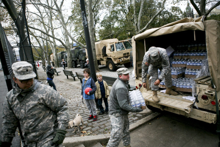
National Guard members delivered supplies at the Red Hook Houses, which had no power or water for weeks after the storm (Photo by Kirsten Luce/The New York Times/Redux)
For most of Red Hook and New York’s existence, however, flood risk wasn’t on anyone’s mind. The city’s decades of rapid growth through the 19th and 20th centuries happened to overlap with a period of meteorological quiet. In 1821, a hurricane hit New York City squarely, producing what is now estimated to be 10- to 11-ft storm surges. (The storm surge at the Battery in lower Manhattan during Sandy reached a record-high 14.06 ft.) But in the early 19th century, New York’s population was little more than 100,000 people, and the tidal ponds that filled Red Hook at the time would have absorbed much of the flooding.
After the 1821 hurricane, New York wouldn’t experience a storm of similar magnitude until Hurricane Donna in 1960, and even the decades that followed were calm until Sandy. That was a lot of time for New York to grow into one of the biggest cities in the world, all without having to worry about storm surges. “New York has been thumbing its nose at the sea for hundreds of years now,” says Ted Steinberg, a professor at Case Western Reserve University and the author of the book Gotham Unbound: The Ecological History of Greater New York. “Leaders should have known that the city was uniquely vulnerable to flooding because of its location. Sandy was a wake-up call.”
Preparing for the Next One
To their credit, New York’s leaders have mostly answered that call. Even before the storm, then-Mayor Bloomberg had convened the city’s own panel on climate change, which presciently warned that global warming and sea-level rise were raising the likelihood that New York would be hit by a major flooding event. After the storm, the city released a 438-report that outlined the city’s plans for resiliency, including 257 separate projects, and Mayor de Blasio has kept those plans going. The MTA will be spending billions to fix the New York’s extensive subway system, much of which was flooded by Sandy, and to fortify public transit against the next storm, installing thousands of rapid-deployment covers to ensure the underground system stays watertight next time.
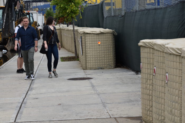
A line of four-foot Hesco barriers has been installed along Beard Street to protect against storm surge (Photo by Steve Koepp)
New York’s Housing Authority, which oversees the city’s 2,600 public-housing buildings, will be spending $3 billion from the federal government to repair the catastrophic damage suffered during the storm. (A fair number of New York’s public housing projects—including the Red Hook Houses—sit near the water, and many of the buildings were in a state of disrepair well before Sandy struck.) “I think you can say the city is on the right track,” says Henk Ovink, a Dutch architect and the former senior advisor for President Obama’s Hurricane Sandy Rebuilding Task Force. “And you can also see we need to pick up our game.”
Ovink was the driving force behind Rebuild By Design, the most ambitious of New York’s post-Sandy recovery projects. Launched by Obama’s Housing Department and the Rockefeller Foundation and other organizations, Rebuild By Design invited architects and designers to dream up the most innovative—and green—ways to create a more resilient New York. And it made financial sense—while the winning efforts for Rebuild By Design were funded with a total of $930 million, studies have shown that each dollar spent on disaster mitigation saves $4 on post-disaster spending.
But as the years have passed and memories of Sandy have receded, some of the momentum around the most ambitious efforts has been lost. Take the biggest project to come out of Sandy: the Big U, conceived as 10 continuous miles of flood protection wrapping around the shoreline of lower Manhattan. Instead of a single wall against floods, the Big U would incorporate greenery and parks. “[They] can capture stormwater runoff,” says Ovink—and indeed, when much of the coastline around Manhattan and Brooklyn was still wetlands and tidal ponds, that’s exactly what happened.
Those days are long gone. Streets and buildings now run up to the water’s edge, often on land that used to belong to the water. And while the Big U would provide a welcome return to a softer and more resilient coastline, ground has yet to be broken on the project. (The city has said that it expects to start construction by late 2018 to early 2019.) Indeed, virtually none of the most ambitious flood-protection projects that were considered in the immediate aftermath of Sandy—including a massive sea barrier spanning New York Harbor south of the city—seem likely to happen any time soon. The Big U could come in at some $3 billion, while that larger flood barrier would cost billions more.
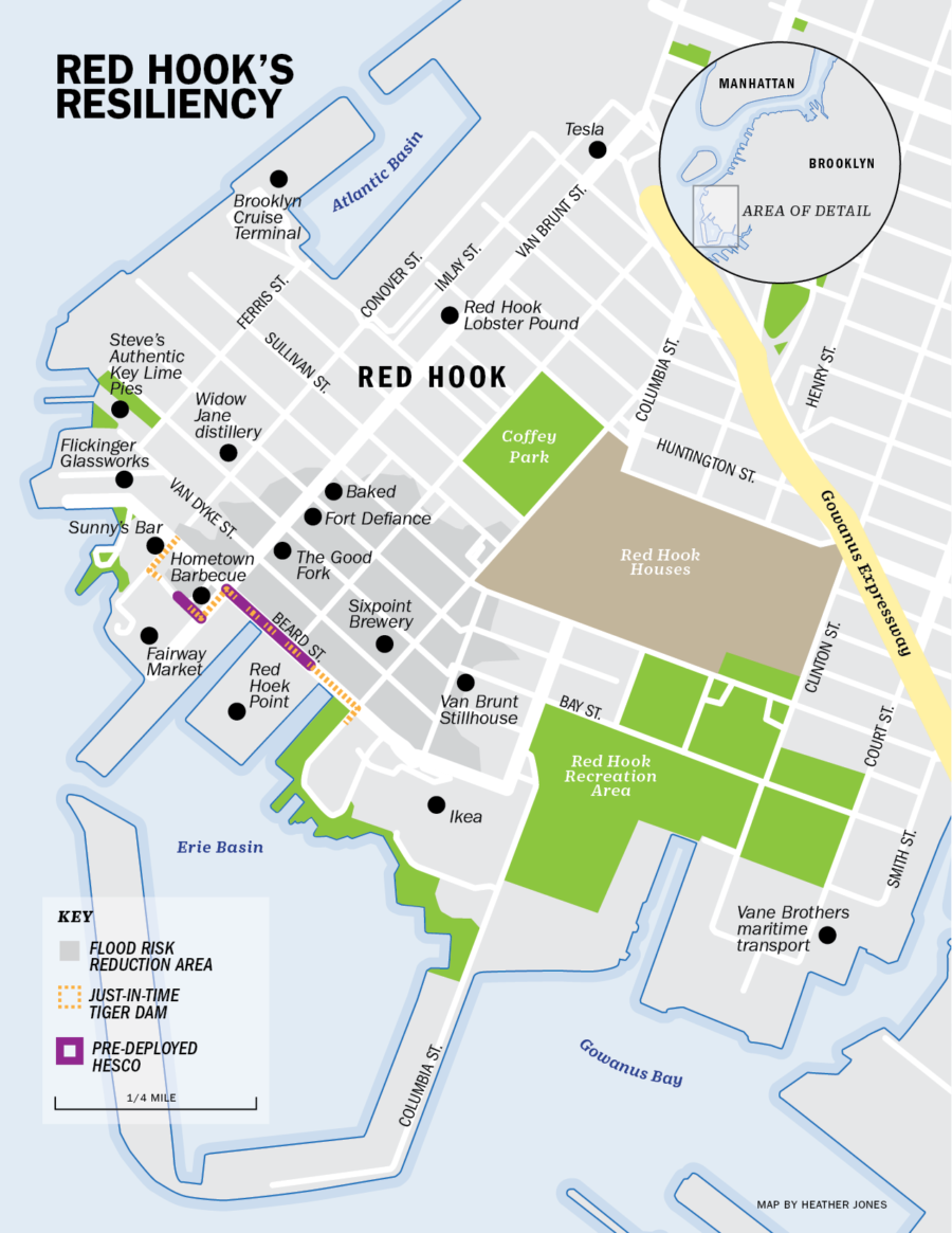
Red Hook has experienced that shrinking of ambition on a smaller scale. Running down the water-facing Beard Street from the Fairway Market to the vast Ikea megastore, as well as on a stretch of Reed Street, is part of Red Hook’s Interim Flood Protection Measures. The four-foot-tall Hesco barriers are made of blocks filled with sand—openings in the wall, which are needed to allow passage on driveways, can be blocked with inflatable barriers in the days before a storm. The Red Hook system represents the first neighborhood-level use of the Hesco barriers, and it is meant to be a first step. the more permanent plans for the Integrated Flood Protection System include raising Beard Street and building a flood wall underneath it, as well as putting a second flood wall in nearby Atlantic Basin.
But those more permanent projects are dependent on federal funding that seems somewhat less likely with President Trump in office. (Just days before Hurricane Harvey inundated Texas, Trump revoked Obama-era rules that would have required the federal government to take into account the risk of flooding and sea-level rise when constructing new infrastructure or rebuilding after disasters.) “It’s great that this system is in place, but it’s only going to cover a small portion of the neighborhood,” says Russell Unger, the executive director of the Urban Green Council, a non-profit that works on sustainable building.
The city has said that Red Hook’s measures will protect against a 10-year flood—meaning a flood that has one-in-10 chance of happening in any given year. Sandy was worse than a 100-year flood—studies after the storm showed that the flooding was significantly worse than what the Federal Emergency Management Agency (FEMA), charged with maintaining flood maps, had expected for a 100-year flood. “If it was a Sandy-level storm, [the barrier] would not protect it,” Jessica Colon, a senior policy advisor for the Mayor’s Office of Recovery & Resiliency, told the audience at a public presentation in Red Hook in June.
That would be worrying enough if Sandy were the worst New York could ever expect. But it’s not. Thanks to climate change, Sandy will just be the start.
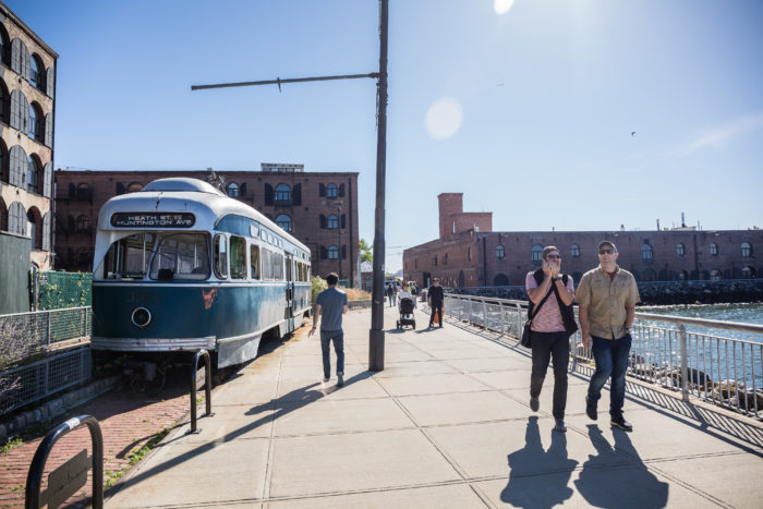
Red Hook is beloved for its waterfront and reminders of its industrial past, including this street car near the Fairway supermarket (Photo by Timothy Fadek)
The Long-term Rising Tide
Sandy would have been a catastrophic storm even without the effects of climate change. But the waters around New York had already risen by about a foot over the past century, which added to the storm surge, just as raising the floor of a basketball court would make it easier to reach the basket. And in the decades to come the seas will keep rising—as soon as the 2050s, upper estimates suggest that sea-level rise could reach two and a half feet. (As if climate change isn’t bad enough, the land in New York is actually sinking, accentuating the effects of sea level rise.) The New York City Panel on Climate Change estimates that a 100-year storm under that amount of sea level rise could result could result in 72 square miles being flooded—nearly a quarter of the city. “With sea-level rise, a given hurricane is going to cause worse damage,” says David Titley, the director of the Center for Solutions to Weather and Climate Risk at Pennsylvania State University and a former rear admiral in the U.S. Navy. “What we had called the 100-year or 500-year floodplain simply isn’t anymore. These waters are coming in.”
They will be coming in more often, too. In a paper published in the Proceedings of the National Academy of Sciences on Oct. 23, Professor Andra Garner, Benjamin Horton and their colleagues looked at the latest science on the impact of climate change on New York coastal flooding risks. They found that, thanks mostly to sea level rise, the frequency of near Sandy-level floods would change from approximately every 25 years now to as often as every five years between 2030 and 2045. That’s soon—you could buy a condo with a water view in Red Hook, and you might be experiencing that level of flooding before your 30-year mortgage is paid off.
And it’s not because stronger hurricanes will hit more often—the researchers actually found that any expected increase in tropical-storm power will likely be offset in the future by shifting weather patterns that steer hurricanes away from New York. It’s because the seas will rise even faster than we expect, leaving New York—at least as it is now—at near-perpetual risk of devastating floods, like a bathtub filled to the brim. “These results are quite shocking for New York,” says Horton.
Climate Central, a Princeton-based nonprofit that analyzes climate science, has created interactive maps that try to predict how coastal cities will ultimately be affected by the sea level rise that will be caused by different rates of warming. Under a scenario with 2 degrees C (3.6 F) warming—which is the increasingly difficult to achieve goal of the Paris Climate Agreement—Red Hook is eventually submerged, as is nearby Gowanus. (You don’t want to know what the 4 degrees C (7.2 F) maps look like.) While it’s difficult to predict exactly how long it will take a set amount of global warming to increase sea levels this much, it will happen—and the latest science suggests it will happen sooner than we long thought. Without significant and costly defenses, the waters will ultimately retake Red Hook and many other shoreline New York neighborhoods.
With most of the neighborhood only a few feet above sea level, Red Hook is vulnerable to the rising ocean (Photo by Lucas McGowen, via drone)
Professor Klaus Jacob, a geophysicist at Columbia University’s Lamont-Doherty Earth Observatory, has long warned of way rising seas would reshape and destroy New York City. In 2008 he produced a prescient report for the MTA warning that many of its lines would flood with a storm surge between 7 and 13 feet. Jacob’s report encouraged the agency to take steps that ultimately helped mitigate some of the worst effects of Sandy. But he is deeply pessimistic about New York’s long-term future in a warming climate—and deeply frustrated that despite the evidence left by Sandy, the city continues to put new developments in vulnerable shoreline areas, including Red Hook.
At a 2016 speech to the New York chapter of the American Institute of Architects, Jacob showed slides of a proposed development along the Red Hook waterfront would be accessible only by ferry by 2100, because the rest of the neighborhood would be underwater. “We have already problems in the current sea level,” Jacob said in his talk. “We know that sea level rise will amplify those risks. We can go about it by protection, and that’s largely what we’re doing, but I think it’s not sustainable in the long run. We can do accommodation again, but it’s an interim [solution] … And we have strategic relocation. And I suggest that this is the only truly sustainable solution.”
A Commitment to the Waterfront
In the aftermath of Sandy, Mayor Bloomberg made it clear that, whatever the city would do to strengthen its defense, it would not pull back from the water. “We cannot and will not abandon our waterfront,” he said. “It’s one of our greatest assets. We must protect it, not retreat from it.” And that, ultimately, is what the city has tried to do, in fits and starts, in the five years since Sandy. So has the construction sector—many of the new condos and other developments being built along New York’s waterfront, including in Red Hook, will have their own protections against rising seas and floods. “We’re living in a world in which technology has changed how construction can happen,” says Carlo Scissura, the president of the New York Building Congress. “We can do things the right way.”
The city has a powerful incentive to keep building along the waterfront: population. New York already suffers from an affordable-housing crisis, and one of the only solutions is to build more housing in neighborhoods like Red Hook where vacant or underused industrial space—often along the water—can be converted to residences. Yet to do so is to put more people in the path of the next Sandy—or to lock New York into spending unimaginable amounts of money on massive flood protections just to keep the city dry.
That is the essential urban quandary of the 21st century, as city leaders are left to adapt to a climate threat that, as Horton notes, “the globe could have solved for far less 20 years ago.” With Trump in the White House, that’s even less likely—the U.S. has already announced it will withdraw from the Paris Agreement on climate change, and this month EPA Administrator Scott Pruitt moved to repeal former President Obama’s greenhouse gas emission regulations. “From the greater focus of reducing emissions, we’re moving more and more to adaptation, and thinking about how cities can be effective at the local level,” says Armando Carbonell, the head of urban planning at the Lincoln Institute of Land Policy.
Fortifying the Neighborhood
The good news for vulnerable neighborhoods like Red Hook is that there is still much that can be done in the near term—and that adapting to sea-level rise and climate change involves more than hard sea walls. Existing buildings, even decades-old brownstones, can be renovated in ways that make them less vulnerable to frequent floods, by moving boilers and electrical equipment above flood levels. (New or “substantially renovated” buildings are required by law to make these changes.) The IKEA superstore in Red Hook was able to weather Sandy thanks to a design that elevated vital equipment and merchandise. The floodwaters mostly washed through IKEA’s ground-level parking lot, while an on-site generator enabled the store to reopen just a couple of days after Sandy hit. While other businesses in Red Hook were knocked out by the storm for weeks or even longer, IKEA became a nerve center for the neighborhood’s recovery.
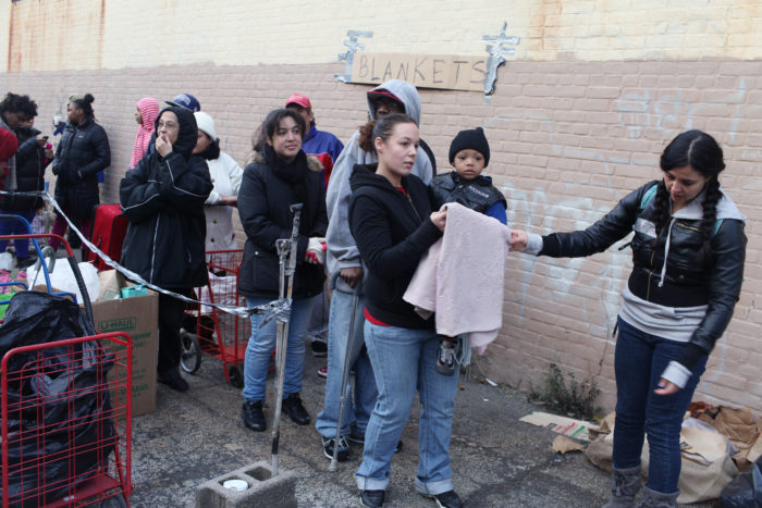
To help people who lacked heat, volunteers brought blankets and other supplies to the neighborhood (Photo by Andrew Lichtenstein)
And that recovery was driven by the same independent spirit that has characterized Red Hook from its birth. Volunteers from groups like the Red Hook Initiative and neighbors from down the street came together to provide hot meals, information, and even access to generators for residents—especially at the Red Hook Houses—who needed help. That included work to deliver supplies directly to the many in the neighborhood who were housebound. (Homes in Red Hook may be selling for millions of dollars, but the neighborhood as a whole has a 45% poverty rate.)
In the years after the storm, a coalition of neighborhood nonprofits put together the Ready Red Hook program, a disaster preparedness plan that focuses on helping the community in the first 72 hours after a catastrophe, the vital window before additional assistance from the city or federal government is likely to arrive. That made Red Hook the first New York neighborhood to complete its own community recovery and disaster response plan. “This may not sound like a climate-mitigation effort, but it makes a difference to work with the community on efforts like this,” says Ronald Shiffman, a veteran city planner and a professor at the Pratt Institute.
Here’s a hard truth: no one really knows how to adapt to the coming climate-related floods. So much of urban planning, or any kind of planning, is built on the past. But as climate change accelerates, the past no longer provides an accurate map to the future—even a past event as recent as Sandy. “The solutions of the past won’t protect us from the future,” warns Ovink. To survive a wetter and warmer tomorrow, neighborhoods like Red Hook will need to be creative and flexible, and they’ll need help from the city and the federal government. But most of all, they’ll need to depend on themselves.