Why Cuomo’s Plan for Red Hook Faces a Force of Nature
The governor proposes vast new housing and a subway extension, but the Brooklyn neighborhood is one of the most vulnerable to rising sea levels


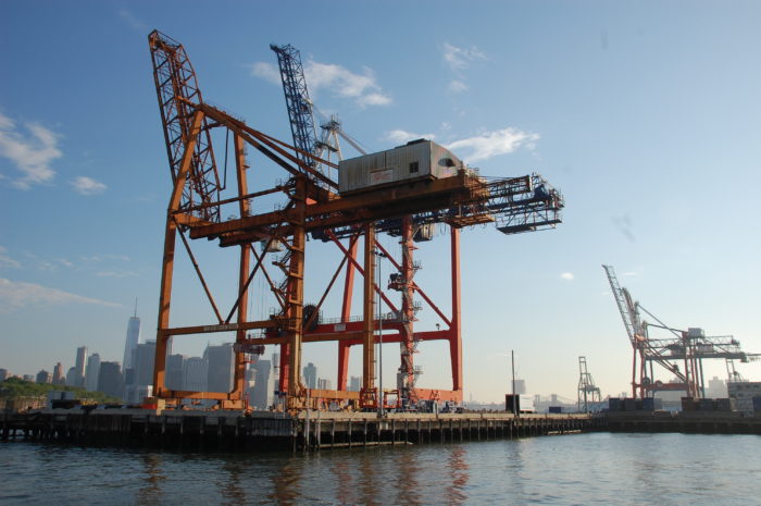
Cranes for handling shipping containers at the Red Hook Terminals (Photo by Steve Koepp)
Here’s a fact about New York. The city has an undeniable housing problem—tens of thousands of New Yorkers are homeless, and rents increases have outpaced income rises for years. While rent regulations can be strengthened and pressure can be put on developers to set aside more affordable units, the most straightforward way to deal with a housing shortage is to build more housing. And in New York—as we’ve seen in Williamsburg and Hudson Yards—the easiest place to build new housing is on the waterfront, often replacing the declining shipping industry that once defined the city.
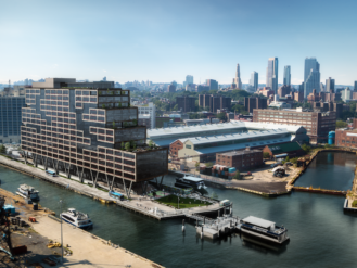
Last week, in a handful of lines from his State of the State speech, New York Governor Andrew Cuomo raised the possibility of another new waterfront housing development, this time in the rising Brooklyn neighborhood of Red Hook. Cuomo called for the Metropolitan Transit Authority (MTA) to consider relocating the the Red Hook marine terminals further south to Sunset Park, which would clear more than 130 acres of publicly-owned waterfront. He also asked the MTA to “study the possibility of a new subway line to stimulate Red Hook’s community-based development.”
The Red Hook plan was one of just dozens initiatives mentioned in Cuomo’s speech, but the scale would be staggering. A subway stop would help solve the transportation isolation that has stemmed Red Hook’s residential growth for decades, while the sheer amount of land that could be redeveloped if the marine terminal is moved would be six times bigger than the $25 billion Hudson Yards complex, currently the largest private real estate development in the U.S. That could potentially mean tens of thousands of new apartments for housing-strapped New Yorkers.
The Bridge contributor Bryan Walsh appears in this video on Red Hook, produced with Brooklyn's BRIC TV (Video by BRIC TV via YouTube)
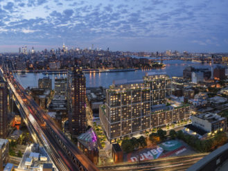
But here’s another fact about New York. With its 578 miles of shoreline, few cities in the U.S. are more vulnerable to climate change-driven sea level rise—and within New York, few neighborhoods are more vulnerable than low-lying Red Hook, which is surrounded by water on three sides. Superstorm Sandy inundated Red Hook, flooding the Fairway Market and the Red Hook Houses alike. Though early steps have been taken to protect Red Hook from future floods, and more are planned in the years to come, without much more ambitious and expensive barriers, Red Hook is almost certainly going to lose the battle against climate change.
Persistent flooding is a big enough threat to a neighborhood of about 10,000 people, Red Hook’s current population. But if Red Hook’s redevelopment goes forward, tens of thousands of additional people will be moving into the highest-risk flood zones. A subway extension into Manhattan, which would require a new tunnel beneath the East River, would be another point of climate vulnerability. (Just ask Williamsburg residents how they’re planning to cope with the 18 month-long closure of the L train’s Brooklyn-Manhattan segment, which suffered catastrophic damage during Sandy.) After the most expensive year on record for natural disasters in the U.S., at a moment when climate-change experts are urging a managed retreat from the rising seas, New York is poised to double down on its waterfront.
Of course, the Red Hook redevelopment may never happen. Earlier plans by the engineering firm AECOM to turn Red Hook into the next Battery Park City have gone nowhere, and if the badly over-budget Second Avenue subway and Number 7 line extensions are any indication, building a new underwater subway tunnel—the first in decades—could be prohibitively expensive. Existing Red Hook residents may fight a development plan that would so utterly change the character of their sleepy neighborhood.
But even if Red Hook remains unchanged, waterfront redevelopment won’t stop—and neither will New York’s growing exposure to sea-level rise. Hudson Yards, the Brooklyn Navy Yard, the new luxury apartment towers in Williamsburg—they all lay within the city’s projected 2050 floodplain. Developers can take actions to protect individual buildings from flooding—already the case with some of Red Hook’s newest high-end waterfront projects—but that adds cost. And it won’t do residents much good if their apartments remain high and dry but the subways and other infrastructure they need is flooded out.
Read our recent three-part special report on Red Hook’s vulnerability, the recovery of its businesses after Sandy, and a tale of two dwellings in the flood zone.
But the bulk of New York’s recent residential development hasn’t been done on the shoreline just because buyers’ love a water view—though that does play a part. Building along the waterfront is usually the easiest option in an already crowded city. The waterfront is often publicly owned, as is the case with the Red Hook terminals, and industrial tenants can be moved, if they haven’t already left the space vacant. There are fewer community groups to tussle with, few historic landmarks that must be preserved. Often waterfront land is simply created—Battery Park City was reclaimed from the Hudson River with landfill left over from the construction of the World Trade Center and other projects, while Red Hook was marshland and tidal ponds before it was filled in.
This drone-flyover video provides an aerial tour of Red Hook, noting areas affect by Hurricane Sandy (Video by The Bridge via YouTube)
After Sandy, then-Mayor Bloomberg said that New York “cannot and will not abandon our waterfront.” But we shouldn’t be surprised when the water reclaims land that was taken from it. This is New York’s dilemma in a time of the housing and climate crises. The simplest solution to the first will almost surely make the second worse.
This doesn’t mean that New York needs to stop building new housing—nor can it. But sustainable and affordable growth in a warming world could mean eschewing the waterfront for denser housing on higher land. The good news is that as much as New York is a city of the coast, it has plenty of high ground in Upper Manhattan and through parts of Queens and Brooklyn, including (as the names suggest) Park Slope and Jackson Heights. The downside: unlike the industrial waterfront, that land is already settled, and NIMBY-minded communities may not take kindly to greater density. We may find out soon which has a more implacable will—the rising seas, or New York homeowners.